Oro Atacama

It is a project of exploration and exploitation of 3 gold mines located between 25 and 70 km south of Copiapó:

A) India Coya, B) Los Sapos and C) Pepita, all near the Pan-American Highway. It is estimated a potential of inferred and indicated mining resources in the order of 500 thousand ounces of gold.

India Coya Mine
It consists of a gold-copper veins system, with a general NS strike, hosted in an intrusive (granodioritic) of Cretaceous age. It is located 25 km south of Copiapó and 5 km from Route 5 (Pan-American Highway).

The following veins have been recognized:

1.- Principal Vein. Where all the exploration work has been concentrated, consisting of tunnels that follow the strike of the vein, identified as: Main Ramp, Upper tunnel and Bottom tunnel, and numerous interior and some surface drilling. The Principal Vein occurs in a structural zone with bands of argillic alteration, pre and post mineral faults, wall rocks with siliceous and / or silica-argillic alteration. It is extensional in nature, generating sigmoid forms throughout its run and its dip. Its exposed run is 450 m, its wide ranges from a few centimeters to more than 5 meters. Its dips varies between 40 ° and 70 ° east. The Main Ramp is a tunnel 5×4 m of 800 of tillage, built to perform the underground drill holes program to recognize the veins. It has a ventilation chimney of 80 m. The ramp is designed for exploitation. The Lower tunnel is 300 meters long with chimneys. The Upper tunnel, is 110 meters long.

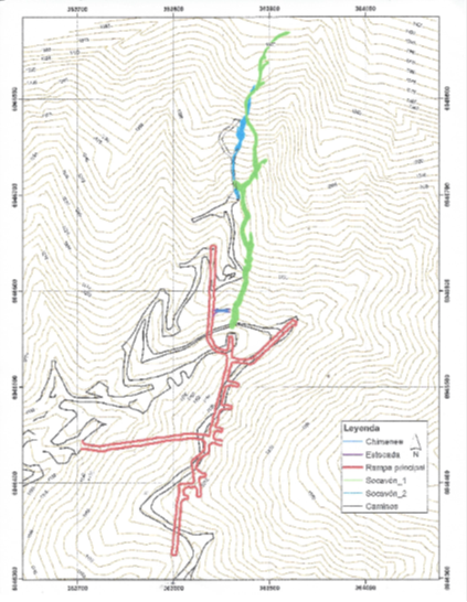
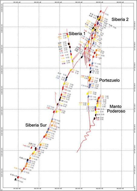
The other veins of India Coya, with almost no exploration, are:

2.-  Corte Camino Vein. It is the southern continuity of the Principal Vein, has an average wide of 1.6 meters with a dip between 50° and 55° East and a visible trend of 400 meters.

3.- East vein, follows a parallel course, 40 meters east of the Principal Vein. It presents average wide around 1 meter. Its dip is variable between 42° and 62° to the East.

4.- Camino vein, composed of hydrothermal silica together with abundant iron oxides, goethite type. It has a visible trend of 150 meters, a NS-N20° W strike and an average wide of 1.6 meters.

5.- Desmonte vein, continuity south of the East vein. It is a vein of calcite. Trend of 120 m, and evidence of copper mineralization in 40 meters, wide of 0.3 to 1 meter, with dip between 52° and 84° east.

6.- Green vein, characteristics similar to the previous one. Its trend is 125 meters with wide of a few centimeters to 2.5 meters and 42° and 74° east.

7.- Black vein is located 350 meters south of the Desmonte vein, with reduced mineralized portions, since the thickness corresponds to veins of calcite with replacement by  silica along 80 m and wide of 10 meters. However, it showed the highest gold value in surface samplings, 12 gr/ton Au. It could correspond to the southernmost continuity of the Principal vein, with a displacement due to faulting to the East.

8.- Chica vein, mineralization of hydrothermal infill of  tectonic breccias; presents iron as specular hematite. Trend of 35 meters, medium wide of the order of 1 meter and dip of 53° to 84° to the West.

Drill holes program

Drilling campaign

In the Principal vein of India Coya, a drilling campaign was carried out from the interior of the mine.  For this purpose the ramp was developed by the footwall of the mineralized structure, from where 15 drilling platforms were built, from which were drilled from 2 and up to 12 holes in fan distribution, according to vertical planes with different azimuths. In such a way that the places where they intercepted the structure, generated an approximately regular mesh of 25 x 25m. In total, 8,000 meters were drilled in 100 DDH drill holes. The obtained results confirm the presence of the Principal structure, with wide and grade that allow interpreting at least three mineralized lenses, the first (northern lens) very well detected by this campaign is located along the northern branch of the ramp and two (central and southern lens) moderate to poorly determined, located in the south branch. The structure was recognized with drillings up to 220 meters deep.

The structures are open in depth and in strike. By comparison with other similar veins in the region, hosted in intrusive rocks, it is estimated that it could have 500 to 800 meters of mineralization at depth.

Considering for this lens: 201 meters long, 150 meters high, average wide of 3.11 meters and specific weight of 2.55, 239.104 tons are obtained with an average grade of 7.91 g / t Au equivalent, which gives a reserve of 60,814 ounces. The potential of the Principal vein could be in the order of 250,000 ounces of gold equivalent.

Principal Vein Longitudinal Section
Principal Vein Cross Section

B) Los Sapos mine

It is located 70 km south of the city of Copiapó, and 15 km from Route 5. It is a district of veins filled with quartz, with gold content of 1 to 20 g / t. The general strike is N10º-20ºE; the wide varies from 0.2 to 2.5 meters, with an inclination of 75º to 85º to the NW. Locally the veins are vertical or with slight inclination to the SE.

In many sectors there is a development of stockworks in the wall rocks of the veins of 0.5 to 3 meters of power on each side or on one side. This stockworks contains, in some sectors, gold mineralization similar to the vein, which increases the exploitable thickness.

There are three main veins, the largest is 2.5 km long and two veins 0.5 and 1 km long. In addition there are several minor veins, from 100 to 250 meters of run. The majority has been exploited in the first 10 to 20 meters and some sectors, such as in the Siberia mine, up to 80 meters deep.

The outcropping rocks are andesites, brecciate andesites, and calcareous sandstones of the Cerrillos Formation of the Upper Lower Cretaceous. Its average strike is N40ºE and dip of 35ºSE. Aphanitic dykes are common, from 1 to 8 meters of wide, from NW to NE, which locally form a wall rock  of some veins.

Los Sapos Mining Rights
Geological Map
Los SaposSurface Sampling

Los Sapos mine resources

Considering all the exploitable veins, there are approximately 4,000 lineal meters of veins. Estimating an average of 1 meter of power with specific weight of 2.7 and only 50% of exploitability (by the rosary effect), a potential cube of 500,000 tons is obtained for every 100 meters of depth. With a probable average grade of 6 g / t, that cube or mineralized nail would have 100,000 ounces of gold.

To date, two drilling campaigns have been carried out with 3,400 meters of DDH drilling, only in the northern part of the district (30% of the vein area), defining isolated sectors with proven and probable reserves of 35,000 ounces of gold. An inferred resource potential of around 250,000 ounces of gold is estimated for the district.

C) Pepita mine

It is a vein of 500 meters of extension and 2 to 5 m of thickness, with NS strike and inclination 70° to the E. It has been very little explored and exploited.

Considering an average wide of 2.5 meters and a depth of 150 meters, a potential of 500 thousand tons is estimated. The probable grade would be                                                  

between 3 and 5 g/t Au (48 to 80 thousand ounces).

Pepita Vain (mining concession Pepita 1-3)